Currently open mapping tasks in woodland
Posted: 26 May 2008, 14:19
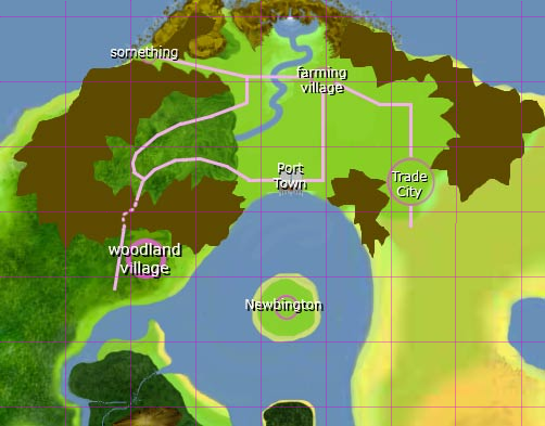
Here a map of the current development of the woodland area. The arrows indicate places where new maps can be added:

The maps which follow these arrows should look like this:
1: (Taken by Zipon) A forest map with cliffs at the western and southern border. The road should be continued and forked to the north and east.
2: A cliff map with a lot of very high cliffs and few open areas. May end in a forest or a seashore in the west.
3: (Taken by Superkoop) A forest map with cliffs in the north. The road can be continued to the south or west.
4: (Taken by Superkoop) A forest map with few or no cliffs and water. The water area at the western border of map 14-1.tmx should be filled.
5: (Taken by Arkyan) A very dense forest map with a river at the western and southern border.
The map 1 has currently the highest priority because it forms the link to the next city project. The maps 3 and 4 are less important from the geographical and development point of view and thus would be a good training task for a less experienced mapper. The maps 2 and 5 have the lowest priority because map 2 would be much better with support for multiple walk layers and map 5 would look better with the new forest tiles by Saphy and Len.
When you create new maps then please try to use the size of the maps 9, 14, 16 and 18 (140x120 tiles). The map 27 is much too large. We only included the map because it is a) very good and b) in a location where it doesn't disturb further mapping too much.
Here the current development plan of the area:


